Newtown
- Country: Alderney, The Channel Islands
- GPS: 49° 43' 7.9212 N, -2° 11' 45.6 W,
- Address: Off Clos de Mer, Newtown
- Operational: 01/07/1942 - 01/03/1944
By Caroline Sturdy Colls and Kevin Colls
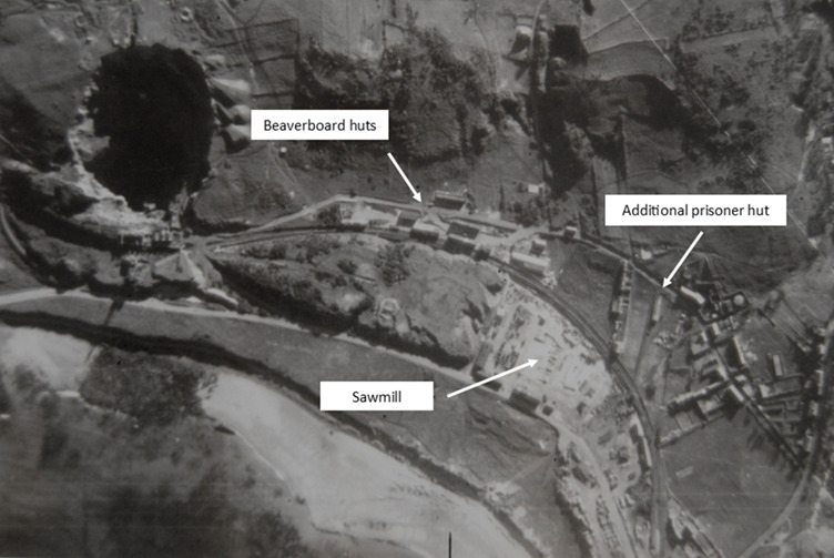
The Newtown camp, situated off what is now Clos de Mer, comprised of a group of beaverboard huts surrounded by barbed wire. Maps and aerial photographs confirm that construction of these buildings had already begun in March 1942, and, by July 1942, the camp consisted of nine structures.1 The proximity of the camp to a sawmill run by the Deubau firm suggests that its inmates were either working here or at the nearby quarry.2 Informants who testified to the British Military Intelligence Division M.I.19 stated that the camps in the Newtown area were also used to house the early transports of French Jews and German political prisoners sent to the island in 1942, so it is likely that a large proportion of this group was held in this camp.3
Unfortunately, in the absence of records, the exact number of people housed there, and details of their experiences are unknown. However, the fact that this camp comprised nine buildings suggests that it was intended to house much larger groups of workers than the other smaller camps across the island and designed to be more permanent. In fact, this camp was larger than the initial floorplan of Sylt labour camp (which housed a minimum of 100–200 labourers in autumn 1942) but smaller than that of Helgoland (which housed around 1,500 labourers).4 That said, estimates based on the number and size of the structures are speculative since it is known from other Nazi camps that the numbers of individuals housed in specific buildings varied considerably and it is not clear which of the nine buildings were accommodation barracks for labourers or for how long they were used in this way. The camp, and indeed the sawmill, were vacated by March 1944 and the buildings were eventually dismantled. Houses now exist in this area.
Further west on Newtown Road, was a hut surrounded by a barbed wire fence, which reportedly housed another contingent of political prisoners.5 This compound was visible on an aerial photograph dated 23 March 1942. It’s proximity to the camp of beaverboard huts described above, but its separate nature, suggests a desire to keep the prisoners in the two camps apart.6 This area is now open grassland but some structural remnants that appear to relate to the former hut are visible.
References:
1 NCAP, ACIU MF C0813, 23 March 1942; NCAP, ACIU MF C0979, 20 July 1942.
2 TNA, HO 144/22834, ‘M.I.19 RPS 2141, Report, Channel Islands, Alderney: Further Interrogation of Informants of M.I.19 (RPS) 2122 and 2136’ 19 April 1944.
3 Ibid.
4 C. Sturdy Colls and K.S. Colls. ‘Adolf Island’: The Archaeology of the Occupation of Alderney (Manchester: Manchester University Press, 2022).
5 TNA, HO 144/22834, ‘M.I.19 RPS 2141, Report, Channel Islands, Alderney: Further Interrogation of Informants of M.I.19 (RPS) 2122 and 2136’ 19 April 1944.
6 NCAP, ACIU MF C0813, 23 March 1942.
Map
- Cemetery / Mass Grave
- Concentration Camp
- Forced Labour Camp
- Prison
- Worksite / Fortification